Sunday, November 28, 2010

L-3 Klein announces the release of the new HydroChart 5000 Side Scan and Bathymetric Sonar System


HydroChart is a revolutionary new tool for Hydrographic surveys


L-3 Communications (NYSE: LLL) announced that its Klein Associates, Inc. division (L-3 Klein) released the revolutionary new HydroChart 5000 Side Scan Bathymetric Sonar System at Oceanology International, in London. The HydroChart 5000 represents the latest technology for the acquisition; display and processing of highly accurate bathymetry data integrated with high resolution side scan imagery, meeting IHO SP-44 Special Order Standards. The HydroChart 5000 utilizes a phase difference measurement technique and Linear FM (Chirp) processing, to produce the highest quality data sets for the hydrographic industry.

The HydroChart 5000 reduces survey times in half compared to conventional surveys using Multi-beam echo sounder systems. The HydroChart 5000 may be hull mounted or pole mounted and is easily integrated with commercial positioning and motion sensing systems. Customers have already benefited from this technology as towed systems developed at L-3 Klein use this same technology to map the ocean’s bottom. The HydroChart 5000 is a true hydrographic tool to effectively and precisely measure depths with a swath of up to 12 times the water depth. L-3 Klein’s internationally accepted SonarPro® acquisition and processing software saves HydroChart 5000 bathymetric and side scan data in industry-standard file formats which allows it to be post processed using third part data processing packages, such as Caris® and Hypack®.

With over 35 years of experience, L-3 Klein is the worldwide leader in commercial Side Scan Sonar systems. The L-3 Klein HydroChart 5000 is another example of how L-3 Klein continuously achieves its goal of bringing the latest in technology to the underwater industry at commercially acceptable pricing. The company offers a wide range of products and services designed to operate in all water depths from a few meters to over 6000 meters. 

“The Difference is in the Image!”

To learn more about L-3 Communications Klein Associates, Inc., please visit the company’s web site at www.L-3Klein.com

Saturday, November 27, 2010

Arctic Explorer to reach out to over 3 million students - KUDOS !!!

Arctic explorer faces a local obstacle

null
Arctic explorer and educator Mille Porsild calls the 22 dogs who live with her in Afton — including Disko whom she is holding — “not just my family — they’re my companions and my partners in what I do.”

Mille Porsild has brought her adventures to classrooms around the world. But her canine teammates have run afoul of an Afton ordinance that restricts private kennels to up to five dogs.

November 26, 2010
Goodie is the alpha male, but the burly and powerful sled dog is bucking that role for the moment as he lies on his back on the frozen ground, looking expectantly for a belly rub.
Across the yard, his female counterpart, Rubi -- so named for her thick, deep-red coat -- looks on with queen-like serenity among the group of 22 dogs preparing for their February Arctic adventure. It will be shared over 16 weeks by 3 million K-12 students in 4,500 schools in 30 countries.
Although Mille Porsild and her dogs have survived what the Arctic has thrown at them in their many trips, they might not be able to get around the Afton Planning Commission and a city ordinance.
The city only allows private kennels to have up to five dogs, said Barbara Ronningen, chairwoman of the Planning Commission, which has discussed the issue over the past two months. "Clearly, she's out of compliance with the ordinance."
A woman who has been pushed to the limits of physical and mental endurance, Porsild is hopeful of finding a resolution with the city so that a mission to which she has devoted so much passion is not undermined.
A veteran of 17 trips to the Arctic since arriving in Minnesota from her native Denmark in 1992, Porsild began working with polar explorer Will Steger. She's executive director and expedition leader of GoNorth! Adventure Learning, an organization tied to the University of Minnesota that teaches students by drawing them into the exhilarating experience of exploring the Arctic. She's also a renowned explorer, Web developer and writer.
Inspired by older relatives who explored the Arctic and two parents who were educators, Porsild has helped pioneer the idea of using Arctic trips as a platform to teach. Starting with hand-cranked generators to power often-unreliable computers at first, she and her team now use Internet video conferencing and satellite feeds.
A passion or 'nightmare'?
Porsild and the dogs can be seen each day training in the hills and fields of rural Afton and Woodbury, pulling a four-wheeled all-terrain vehicle.
"I probably know these guys better than I know my own family," Porsild said. "I mean, they are my family. And they're not just my family -- they're my companions and my partners in what I do.
"I have stood in numerous situations where my life is on the line and they're the ones pulling me out of it. When you have faced a polar bear and these guys are the ones who've made the polar bear go away ... when you have stood on thin ice and the sled is going in and you know it's not a situation where they can pull it out ... It's the most unbelievable experience to see them just come together as this machine. And then off we go."
Those situations seem to make a battle with Afton city officials seem trivial. But it's serious.
Ronningen and Fritz Knaak, the city's attorney, said the ordinance is meant to protect neighbors from potential problems. "There's a reason for these types of regulations -- that's a lot of dogs," Knaak said. "One person's hobby and passion is another person's nightmare."
Ronningen said the only option is to change the ordinance, which has to be requested by a Planning Commission or City Council member or a resident landowner (Porsild rents her acreage). "At this point, there's nothing on the table" to change the ordinance, Ronningen said.
For her part, Porsild said when she arrived in Afton in 2008, it was her understanding she would be given a variance that would allow her to keep the dogs on the property. Because she doesn't board or sell dogs, she also doesn't regard herself as having a kennel.
"The neighbors have been absolutely amazing about it," Porsild said. She is unaware of any complaints, and has worked at training the dogs not to bark or howl. At least two neighbors have come to her defense before the Planning Commission.
"If I have to move -- it would be very serious," said Porsild, who has dealt with government snags many times. Last year, for example, it took a special act of Greenland's Parliament to allow her dogs to sled across that land.
"There's rules, and you have to be respectful of the rules and you have to be respectful to the people who made the rules and why they were made," she said. As for the ordinance, "not much needs to be changed if you want to allow something like this, and that's what it really comes down to."
Despite obstacles, positivity
The clash with the city has been ill-timed with another blow: the loss of funding from the Best Buy Children's Foundation, which has opted to channel money elsewhere. Along with the National Science Foundation and NASA, it had been a key source of support, Porsild said.
It also comes at a time Porsild and her nonprofit organization are looking to expand their educational mission and the adventure learning concept. Porsild envisions it as an umbrella organization to teach people of all ages.
Before each mission north, Porsild pulls together a phone-book-thick curriculum that follows each journey every step of the way.
"Our job then becomes to literally bring this to life from the trail," she said.
The curriculum draws together lessons on the sciences, math, economics, anthropology, language and literature. The Arctic has much to teach, and students respond enthusiastically, she said -- thanks in no small part to the charms of the dogs, whom she calls "the superstars."
"It's about bringing together all the different perspectives into the picture, because that's when students really start learning" she said. "Because what they're really learning is that decisionmaking is hard, and that you have to try and understand all the different aspects to make decisions."
Despite the situation, Porsild remains upbeat and determined. It's a lesson she's learned from her dogs.
On the trail, her dogs don't respond if she doesn't have a positive outlook, Porsild said, citing an example.
"We're on the Brooks Mountain range [in Alaska] trying to climb 5,000 feet with sleds weighing 1,200, 1,400 pounds -- you have to believe it's possible. We're in snow up to our armpits, I mean, we're literally crawling -- and we're underneath the sled pushing, and these guys are in that, they're up to their ears.
"And if I start feeling like we can't do this, they'll literally sit down and look at me."

Jim Anderson • 651-735-0999

http://www.startribune.com/local/east/110889279.html?elr=KArks:DCiUHc3E7_V_nDaycUiD3aPc:_Yyc:aU6:iPhD_oD3aPc:i_kchO7DU

NASA - Global Climate Change Website

http://climate.nasa.gov/ClimateTimeMachine/climateTimeMachine.swf

Friday, November 26, 2010

AUDIT: Canadian Coast Guard unprepared to respond to oil spills (U.S. Coast Guard in same boat?)

Candian Coast Guard icebreaker Louis S. St. Laurent.

Candian Coast Guard icebreaker Louis S. St. Laurent.


OTTAWA — The Canadian Coast Guard lacks the training, equipment and management systems to fulfil its duties to respond to offshore pollution incidents such as oil spills, an internal audit reveals.
The audit paints a sobering picture of an agency that would play a key role in Canada's response to a major oil spill off the world's longest coastline. In the event of a spill leaking from a ship, as occurred in 1989 when the Exxon Valdez ran aground off the coast of Alaska, the Coast Guard would be the lead federal agency in the cleanup efforts.
However, the audit found that Coast Guard employees are trained on an "ad hoc, regional basis," with no national training strategy. Meanwhile, the Coast Guard is relying on aging equipment — the operating status of which it is unable to track — and management controls are "either out-of-date, not functioning or not in place."
"As such, assurance cannot be provided that the conditions exist to enable (environmental-response) services to be provided in a national consistent manner," states the audit, which was completed just over a month before an explosion at BP's Macondo well in the Gulf of Mexico unleashed the biggest offshore oil spill in history this spring.
Under Canada's patchwork response regime, the lead agency would depend on the nature and location of a spill. Off the East Coast, joint federal-provincial petroleum boards would oversee the cleanup of a spill at a drilling rig, while the National Energy Board would handle that responsibility in Arctic waters. But the Coast Guard would take the lead in any spill from an oil tanker, or a "mystery spill" whose origin is unknown.
The Coast Guard's "environmental-response" unit deals with roughly 1,300 reported pollution incidents each year, despite having only about 80 staff and a modest budget of $9.8 million. The agency has 12 staffed depots, with equipment spread across the country at 70 additional locations.
The audit describes an agency that operates more like a loose alliance of regional offices than a national organization.
The audit team "found that there were no nationally consistent, detailed standard operating procedures, only regional operating procedures that are not approved by headquarters."
Internal auditors also found that information about incidents was not recorded in a manner that would allow for the review of incident responses.
The Coast Guard hasn't identified the level of knowledge, skills and tools required for all environmental-response staff, and the agency lacks a way to monitor what training has been received by staff.
Similar issues dog the Coast Guard's equipment-management system, leaving staff with no "current, reliable, up-to-date information on the operational status of equipment."
"The last major investment in equipment in the program was . . . in the 1990s. Since then, there has been no consistent, nationally co-ordinated investment in equipment. Equipment acquisitions are on a regional basis and based on the availability of funding throughout the year," the audit states.
One academic expert who has studied the Coast Guard says the agency has become a "political orphan" that, unlike the Canadian Forces, doesn't get much political or public support when lobbying for budget increases.
"The Coast Guard tends to be one of these organizations that is very professional in what they do, but because most people don't pay them any attention, they're always at the end of the line for any budget," said Rob Huebert, associate director of the Centre for Military and Strategic Studies at the University of Calgary.
Huebert said the federal government should consider arming the Coast Guard with better spill-response tools, given the fact that offshore drilling and tanker traffic is expected to intensify in Canada's Arctic waters. Several oil companies have acquired licenses to explore for oil in Canada's portion of the Beaufort Sea, although drilling isn't expected to take place for at least a few years.
A spokeswoman for the Department of Fisheries and Oceans, which is responsible for the Coast Guard, said the audit's recommendations have been "incorporated into the environmental response work plan.
"Work has started on many of the initiatives and we remain on target for completion," the spokeswoman said in a statement. The Coast Guard recently acquired 20 new "environmental response barges," she added.

FARSOUNDER - Forward looking 3D sonar

3D Sonar Systems
With unique patented technology, FarSounder is challenging the boundaries of sonar technology. From advanced long range 3D Forward Looking Sonars to underwater Diver Detection, FarSounder provides a whole new vision underwater. This technology is suitable for both surface and sub-surface vessels and along waterside perimeters.


GREAT FOR NORTHWEST PASSAGE NAVIGATION !!!


http://www.farsounder.com/


2D vs 3D Sonar Processing

WARNING: Technical Jargon Ahead
FarSounder has approached sonar system design fundamentally different than other sonar technologies. The solution FarSounder's technology provides is the ability to deal with multi-path and water depth issues, allow for fast refreshes, and create a large field of view with single pings, all in a small cost effective package. FarSounder's approach does not hurt marine life and can be used as a marine mammal shipstrike mitigation device.
FarSounder's single ping, 3D sonar approach enables the system to overcome traditional Forward Looking Sonar limitations such as Multipath Interference, Shallow Water Operation, Roll/Pitch Compensation, Surface Effects and Ship Motion.

Figure 1

Figure 2

Figure 3
When used as a navigation device in shallow water, other 2D technologies often fall short of being effective navigation tools. These systems are very good at finding the range and bearing to a single target in deep water. However, by definition, there are targets at every range and bearing in shallow water. Those 2D systems cannot distinguish between the safe sea floor and the dangerous in-water obstacle through depth measurement. They must rely on visual cues to guess whether or not the obstacles are located in the water column or on the sea floor. The need for visual cues forces those 2D systems to have very high horizontal angular resolution. Unfortunately, this causes the systems to require many listening channels and requires a footprint for the receive array or lens aperture that is very long in terms of wavelengths. This long aperture requirement drives the systems to a higher frequency which in turn excludes them from long range capabilities.
To illustrate the difference between these two approaches consider the following figures.
In figure 1, real data of a pier wall bulkhead collected with a FarSounder 3D sonar system is processed as a simple 2D horizontal slice. In this display, color is mapped to signal strength where red is "loud" and blue is "quiet". The angular resolution is roughly equal to the existing off-the-shelf Forward Looking Sonars (FLS) -- also called Collision Avoidance Sonar Systems (CASS) or Obstacle Avoidance Sonars (OAS) -- manufactured by various companies. There is clearly a feature caused by the pier wall crossing the field of view at about 45° (noted with the dotted line). Yet there is also another feature or "bright" spot noted by the oval. As a navigation tool, this 2D display is not very effective.
In figure 2, this same ping has been processed with FarSounder's 3D processing using patented Target Model technology. In this image, color is mapped to depth. The view is a look down orthographic projection, yet targets are actually plotted in 3D space. Note the clear presence of the pier wall (shallow) in red and the sea floor (deep) in blue.
In figure 3, the same data is plotted in 3D space with a rotated perspective view. Note how clear it is to see the navigation hazards in 3D with this processing technique.
Without 3D capability, Forward Looking Sonars are unable to easily compensate for roll and pitch without large amounts of expensive hardware. Even in these cases, 2D roll and pitch compensation is marginal at best. FarSounder's technology is capable of compensating for roll and pitch entirely in software with a simple, inexpensive roll and pitch sensor.

Wednesday, November 24, 2010

Sneak Peek - Northwest Passage pictures from others who have gone before us

AUGUST-SEPTEMBER 2010 ICE BREAKUP
POND INLET NU CANADA
BEECHY ISLAND MEMORIALS


BEECHY ISLAND (MV BAGAN AT ANCHOR DURING 2009 VOYAGE)


BEECHY ISLAND MEMORIALS


VIDEO SNIP - SV NORWEGIAN BLUE 2003

Larsen Sound

Playing in the ice

Three year historic Northwest Passage by Roald Amundsen aboard 47ton 12hp GJOA completes in 1906 with 6 crew


Born16 July 1872
BorgeØstfoldNorway
Diedc. 18 June 1928 (aged 55)
unknown
OccupationExplorer
ParentsJens Amundsen, Hanna Sahlqvist

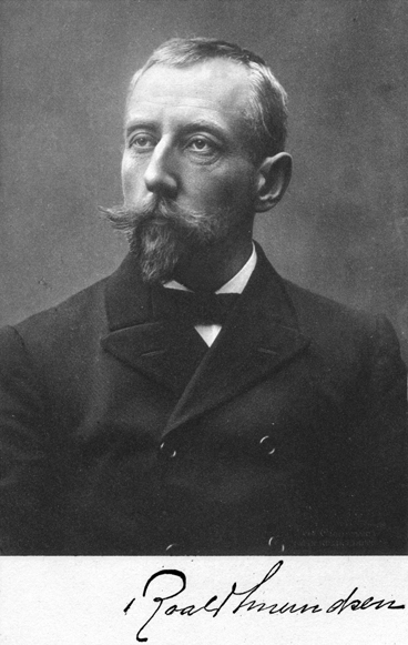
Amundsen, Roald, 1872-1928.  

Roald Amundsen's "The North West Passage"; Being the Record of a Voyage of Exploration of the Ship "Gjöa" 1903-1907. London, 1908. [Rare Books Division]

Amundsen is a name synonymous with polar exploration. Better known as the first man to reach the South Pole, the Norwegian also commanded several other significant Arctic expeditions. As he wrote in his Northwest Passage book's introduction: “It is in the service of science that these numerous and incessant assaults have been made upon what is perhaps the most formidable obstacle ever encountered by the inquisitive human spirit, that barrier of millennial, if not primæval ice which, in a wide and compact wall, enshrouds the mysteries of the North Pole” [Vol. 1, p.2.]. More directly, Amundsen was stimulated by his childhood memories of the failed Franklin expedition of the 1840s and the successful Northeast Passage transit of the Vega by the Swedish geologist and explorer A. E. Nordenskiöld in the 1870s. In 1899, as mate in the Belgian Antarctic Expedition under Adrien de Gerlache, he proposed combining his boyhood dream of completing the Northwest Passage with the scientific aim of locating the present site of the Magnetic North Pole. He won the approval and aid of the veteran Norwegian explorer and scientist Fridtjof Nansen, and raised money, acquired equipment, and bought and outfitted a former herring-boat named Gjöa [see image of it from the book]. Weighing forty-seven tons, the little sailing ship boasted a 13-hp engine, stowed enough food and supplies for five years, and carried an experienced Arctic crew of seven, including Amundsen.
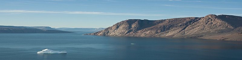
They cast off from Christiania [now Oslo] on the night of 16 June 1903. In creeping up the west coast of Greenland, they were fortunate to have missed the early ice, and reached Dalrymple Rock (their farthest North, latitude 76° 28'20" N), where Scottish whalers had deposited some stores for them, on August 15. From there it was just a week's sailing across Baffin Bay, through the opening of Lancaster Sound, to Beechey Island, where they anchored in Erebus Bay. After exploring the barren island (they found the memorials in good order), scavenging through the old Franklin depot, and completing their magnetic observations, they departed on the 24th, sailing and motoring down Peel Sound and Franklin Strait, past the eastern side of King William Island, through Rae Strait, to the safety of a small harbor on the island's southeastern corner that they christened “Gjöahavn” [today's Gjöa Haven]. It was the middle of September. They had survived a fire in the engine room and a grounding on a submerged reef, and had depended on dead reckoning due to the compass's fluctuations around the magnetic pole. Amundsen decided to winter there to concentrate on magnetic work.

As soon as I saw Gjöahavn, I decided to choose it for our winter quarters. It was evident that the autumn storms had set in in earnest, and I knew the waters further west were very shallow. Before deciding definitely upon this course, I intended to explore the harbour in a boat. The Magnetic Pole, as shown by our observations, appeared situated somewhere in the neighborhood of its old position, and as Gjöahavn was about 90 miles from that locality, it should, according to the dicta of scientific men, be particularly suited for a fixed magnetic station. . . . So why look further west for a harbour, which possibly we should not find. Had the completion of the North West Passage been our chief object, it would have been a different matter, and nothing would have prevented us from going further on. [Amundsen, in his Roald Amundsen's “The North West Passage”, Vol. 1, p. 80.]

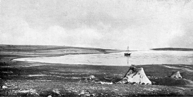
“The ‘Gjöa' at Anchor in Gjöahavn (Summer of 1904)”

For almost two years, Gjöa Haven was their home [see map of their activities during that time] .
Thoroughly interacting with the local Inuit and adopting their clothing, Amundsen's party participated in dog sledding and seal hunting activities in the winter and kayaking and net fishing during the summer—in addition to fulfilling their scientific tasks. A major sledge trip was undertaken in the spring of 1905 by second mate Helmer Hansen and first engineer and meteorologist Peder Ristvedt to the eastern coast of Victoria Island along the remaining uncharted region. They reached their furthest point north, which they named Cape Nansen, on May 26; a month later they were back at the ship, having covered 800 miles. Gjöa and its crew finally departed from Gjöa Haven on 13 August 1905.

I looked forward to the expedition with confidence. We were well equipped, and had good reliable comrades, and smart dogs. We should have been glad of a few more of the latter. But with a good heart and a good will we would manage with those we had. On March 1st we were ready to start. The thermometer stood at 63½ below zero (Fahr.) But in the course of the month of February we had become so used to the cold that it really did not make any great impression on us. We were, indeed, extremely well clad, some of us in complete Eskimo costume, others in a partly-civilised style. My experience is that the Eskimo dress in winter in these regions is far superior to our European clothes. Woolen underclothing absorbs all the perspiration and soon becomes wet through and through. Dressed in nothing but reindeer skin, like the Eskimo, and with garments so loose and roomy on the body that the air can circulate between them, one can generally keep his things dry. . . . A further great advantage of skin is that you feel warm and comfortable the moment you put it on. . . . Finally, skins are absolutely wind-proof, which, of course, is a very important point. [Amundsen, Vol. 1, pp. 146, 149-150.]

“The First Sledge Expedition”

Though there was much ice in Queen Maud's Gulf, Dease Strait was completely clear. However, serious pack ice began advancing down on them from the east near Cape Bathurst. Soon after, they met two American whalers heading to Herschel Island, which was their destination as well, but the ice stymied them, and they were forced to spend the winter at King Point, where the schooner Bonanza from San Francisco had been beached due to damage. Desiring to post mail and wire a telegram of his accomplishment, Amundsen joined the whalers' mail run from Herschel Island to Eagle City (on the Yukon River); they left on October 24 and reached Eagle City a little more than a month later. Waiting for mail from home, he stayed in Eagle City for another two months, but was back at King Point on 12 March 1906. Gustsav Wiik, Amundsen's assistant for magnetic observations, got very sick and died at the end of March and was buried at King Point where their magnetic instrument stand had stood. Ice conditions allowed the group to leave on July 2, but then they were grounded in the harbor on the east side of Herschel Island for three weeks. They made several attempts to continue their journey west, but each time ice forced them back to Herschel Island. They made their final escape on August 9. Along the coast of Alaska they dealt with heavy fog and wind-driven ice; they damaged their propeller shaft near Cape Simpson, and while the mainsail was being set, the gaff broke—fortunately, these troubles were coming at the end of their trip. At Point Barrow, Amundsen received a letter of invitation from the people of the town of Nome. Using the opportunity to obtain a new gaff, they arrived at Nome on 31 August 1906: the celebration there marked the official end of the first successful Northwest Passage voyage. Echoing what other explorers before him had hoped, Amundsen reflected about the situation of the Inuit he had met:
During the voyage of the “Gjöa” we came into contact with ten different Eskimo tribes in all, and we had good opportunities of observing the influence of civilisation on them, as we were able to compare those Eskimo who had come into contact with civilisation with those who had not. And I must state it as my firm conviction that the latter, the Eskimo living absolutely isolated from civilisation of any kind, are undoubtedly the happiest, healthiest, most honourable and most contented among them. It must, therefore, be the bounden duty of civilised nations who come into contact with the Eskimo, to safeguard them against contaminating influences, and by laws and stringent regulations protect them against the many perils and evils of so-called civilisation. . . . My sincerest wish for our friends the Nechilli Eskimo is, that civilisation may never reach them. [Vol. 2, pp. 48, 51.]
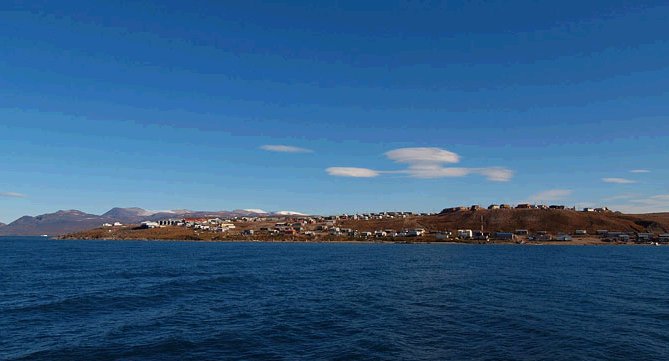
When we got down into the [Bering] Strait, we caught a glimpse of the Diomedes Islands. These look barren and inhospitable . . . As we passed between the islands and the shore, we “old hands” gathered on deck and drank the first cup to celebrate the final accomplishment of the North West Passage by ship. I had hoped to have a little festivity to mark this notable event, but weather did not permit. The event was celebrated by a simple toast, nothing more. . . . Our only hope now was that the wind would hold out till we reached Nome, and could procure a new gaff. We headed south towards Nome under trysail and any other sails we could carry. . . . Suddenly a steam launch appeared in front of us, and we heard whistling, shouting, and cheering—the American's mode of expressing enthusiasm. Dark as it was, we could still discern the Norwegian flag floating side by side with the Stars and Stripes on the launch. So we had been recognised. The reception they gave us at Nome defies my powers of description. The heartiness with which we were welcomed, the unbounded enthusiasm of which the “Gjöa” was the object, will always remain one of my brightest memories of our return. [Amundsen, Vol. 2, pp. 285, 286-287, 291, 292.]
 
Building on his Arctic experience, Amundsen later went on to conquer the South Pole, arriving there on 14 December 1911, thirty-five days before Robert F. Scott.

Amundsen disappeared on June 18, 1928 while flying on a rescue mission with Norwegian pilot Leif Dietrichson, French pilot Rene Guilbaud, and three more Frenchmen, looking for missing members of Nobile's crew, whose new airship Italia had crashed while returning from the North Pole. Afterwards, a wing-float and bottom gasoline tank from the French Latham 47 flying boat he was in, improvised into a replacement wing-float, was found near the Tromsø coast. 


It is believed that the plane crashed in fog in the Barents Sea, and that Amundsen was killed in the crash, or died shortly afterwards. His body was never found. The search for Amundsen was called off in September by the Norwegian Government. In 2003 it was suggested that the plane went down northwest of Bear Island

http://en.wikipedia.org/wiki/Roald_Amundsen


Frigates of the Royal Norwegian Navy

HNoMS Roald Amundsen F311
HNoMS Fridtjof Nansen
HNoMS Otto Sverdrup
HNoMS Helge Ingstad

ImageShack, share photos of hnoms roald amundsen, share pictures of hnoms roald amundsen, share video of hnoms roald amundsen, free image hosting, free video hosting, image hosting, video hosting.

ImageShack, share photos, pictures, free image hosting, free video hosting, image hosting, video hosting, photo image hosting site, video hosting site

Displacement:5,290 tons
Length:134 metres (439.63 ft)
Beam:16.8 metres (55.12 ft)
Draft:7.6 metres (24.93 ft)
Propulsion:Combined diesel and gas (CODAG)
Two BAZAN BRAVO 12V 4.5 MWdiesel engines for cruising
One GE LM2500 21.5 MW gas turbine for high speed running
MAAG gearboxes
two shafts driving controllable pitch propellers
Bow Thruster Retractable (Electric)1 MW Brunvoll
Diesel Generators 4 × MTU 396 Serie 12V 1250 KVA
Speed:26 knots (48.15 km/h)
Range:4,500 nautical miles (8,334.00 km)
Complement:
120 men, accommodations for 146
Lockheed Martin AN/SPY-1F 3-D multifunction radar
Reutech RSR 210N air/sea surveillance radar
Sagem Vigy 20 Electro Optical Director
MRS 2000 hull mounted sonar
Captas MK II V1 active/passive towed sonar
2 × Mark 82 fire-control radar
Electronic warfare
and decoys:
Terma DL-12T decoy launcher, Loki torpedo countermeasure
Armament:1 × 8-cell Mk41 VLS w/ 32 × RIM-162 ESSM
8 × Naval Strike Missile SSMs
4 × torpedo tubes for Sting Ray torpedoes
Depth charges
1 × 76 mm OTO Melara Super Rapid gun
4 × 12,7 mm Browning M2HB HMGSea PROTECTOR
2 x LRAD Long Range Acoustic Device
Prepared for, but not equipped with:
1 × Otobreda 127 mm/54 gun to replace the 76 mm
1 × spare 76mm OTO Melara Super Rapid gun
1 × spare CIWS gun w/ calibre 40 mm or less
3 × spare 8- cell Mk41 VLSlaunchers
Low cost ASW
ECM: Active Off-board Decoy
Aircraft carried:1 × NH90 helicopter


Kongsberg Maritime's HUGIN AUV plays starring role in new film.
 
Kongsberg Maritime's HUGIN AUV is featured in an intriguing new documentary, which investigates the disappearance of Roald Amundsen and his 'Latham 47' sea-plane in the Barents Sea during a rescue mission in 1928. 'Roald Amundsen – Lost in the Arctic', is to have its first screening this Saturday (27th Feb 2010), in Oslo, Norway.

HUGIN 1000 AUV
Equipped with synthetic aperture sonar, HUGIN 1000 provides high resolution acoustic imagery with a resolution of 3 x 3 centimeter.
The new film sees polar explorer Liv Arnesen and Per Arvid Tellemann, a former navy navigator and member of a commission that investigated Amundsen's untimely death uncover the mystery on land, whilst the Norwegian Navy, aboard its vessel KNM Tyr, searches for the wreckage of Amundsen's plane using a Kongsberg Maritime HUGIN 1000 AUVand HISAS 1030 synthetic aperture sonar.
Norwegian Roald Amundsen was one of the great explorers of the early 20th Century, having been the first to reach the South Pole in December 1911 and is also credited with the first verified attempt to cross the arctic in an airship in May 1926. Amundsen vanished along with 6 others when the Latham 47 they were flying crashed during a rescue mission to save the Italian general and aviation engineer Umberto Nobile, whose airship Italia had gone down returning from the North Pole.
The hunt for Amundsen's plane was co-organised by the Norwegian Aviation Museum, the Norwegian Navy and Context TV, a German television production company specialising in documentaries related to scientific-historical expeditions and explorations, with main emphasis on the underwater segment. The expedition started in August 2009, with HUGIN 1000 being used as the primary tool to search for the famous Norwegian arctic explorer's airplane over an area measuring 34 square nautical miles.
HUGIN 1000 is a state-of-the-art AUV with a depth capacity down to 1000 metres, an operational speed of 4 knots and the ability to stay deployed at sea for 18 hours non-stop with all sensors operating. The Norwegian Navy's HUGIN 1000 is primarily used for mine hunting so along with a payload that includes the Kongsberg Maritime developed HISAS 1030 synthetic aperture sonar, it is the ideal tool for hunting plane wreckage over such a large area. If the Latham had been in the search area, then the HUGIN would have found it.
"We are proud to have been part of this project," comments Bjørn Jalving, Vice President of AUVs, Kongsberg Maritime. "The HUGIN 1000 AUV with the HISAS 1030 synthetic aperture sonar has a new level of resolution and range in acoustic imagery and is especially designed to find small, modern mines, efficiently searching large areas. It has therefore been the perfect tool for searching for the Latham airplane."

Monday, November 22, 2010

WASSP - wide angle scanning sonar profiler


WASSP enables seabed profiling at up to 100 times the speed of conventional single-beam echo-sounders, with improved accuracy and significantly reduced cost.
WASSP multibeam sonar technology gives you the power to really see what’s below your boat. It offers unparalleled accuracy, resolution and versatility in a cost-effective package suitable for vessels of every size.

Wassp is easy to operate and delivers a turn-key, multibeam sonar solution that enables you to greatly enhance your understanding and knowledge of the marine environment.

2 Way
Triple Beam
Sonar


  • Enables seabed profiling at up to 100 times the speed of conventional single-beam echo-sounders, with improved accuracy and significantly reduced cost.
  • Easy to use - controlled via a mouse
  • Accurately profiles the water column and seafloor
  • User friendly screen displays including 2d, 3d, back scatter, side scan, triple beam sounder, sonar views, 2 way and 4 way split
  • Data displayed in real time
  • Extra wide 120º port–starboard coverage delivering hi resolution imaging through 112 beams
  • Available in 2 frequencies 160kHZ and 80kHZ for different depth of operation
  • Can be interfaced with GPS compass, roll, pitch  heading, and sound speed inputsto improve seafloor profiling accuracy
  • Includes a buit in tide correction database
 Wassp multibeam sonars accurately profile the water column and seafloor highlighting reefs, wrecks, fish schools, seafloor hardness changes and foreign objects in the water column or on the seafloor. This information is presented in user-friendly displays, all controlled via a mouse and stored on computer hard drive for future use.
Multibeam display options include real-time 3D view, 2D view, normal echosounder, sonar and side-scan sonar views. Each display view option can be presented in full screen or in split screen, to enable users to quickly and easily understand the detailed multibeam sonar information being generated by WASSP.
Importantly, sonar data is displayed in real time for immediate action by skippers with the ability to save seafloor profiles for future reference and to overlay these profiles on existing plotting programs.

3D View
2D View
Sonar

  • 3D View
  • 2D View
  • Sonar

Traditional Sounder
Side Scan
4 Way Split

  • Normal Echo Sounder
  • Side Scan
  • 4 Way Split
 A powerful, patented transmitter pulses a sonar beam over a wide 120º swath port-starboard of the vessel with a pulse rate of up to eight pulses per second. The return sonar signals are received through a custom designed, phased array, receive transducer to resolve 112 dynamic beams within the 120º swath. The result is a multi-beam sonar system with very wide 120º port–starboard coverage, but also very high resolution delivered through the 112 beams.
WASSP Wide
            coverage, high-resolution coverage
 Wassp is available in two frequency options depending upon the required depth performance and resolution requirements from customers. Wassp WMB-160F is a 160kHz multibeam sonar for operation down to 200m depth.
Wassp WMB-80F is an 80kHz multibeam sonar for operation down to 500m depth. Wassp WMB-80F is primarily designed for Commercial fisherman while Wassp WMB160F has three core customers groups – Commercial Fishing, Marine Professionals, Super Yacht.
A WASSP multibeam sonar system comprises of 3 modules – a transducer (incorporating separate transmit and receive arrays), a signal processing box (called a BTxR) and a standard Windows XP display PC (or laptop for portable applications). The WASSP operating software runs on the display PC and manages all functions of the multi-beam sonar, including display functions, storage of information and output of this information to third-party plotting systems. For full details see “Specifications”.
 WASSP transducers can be permanently mounted to the vessel or deployed via a pole, depending on the vessel and application.
 To further improve WASSP performance, GPS compass, roll, pitch and heading, and sound speed inputs can be interfaced to improve seafloor-profiling accuracy. In addition, WASSP includes a built-in tide correction database for almost anywhere in the world, which along with careful attention to ship’s offset – the position of GPS sensor, transducer and roll center relative to the ship’s centerline – results in more accurate seafloor profiles and fish school location.

One of the key factors to the success of the WASSP Multibeam Sonar is the variety of viewing options available and the ease of use for the operator.
Multibeam display options include real-time 3D view, 2D view, normal echosounder, sonar and side-scan sonar views. Each display view option can be presented in full screen or in split screen, to enable users to quickly and easily understand the detailed multibeam sonar information being generated by WASSP.
Importantly, sonar data is displayed in real time for immediate action by skippers with the ability to save seafloor profiles for future reference and to overlay these profiles on existing plotting programs.

2D View
3D View
Sonar

  • 2D View
  • 3D View
  • Sonar

Sonar
Sounder
Triple Beam

  • Sonar
  • Sounder
  • Triple Beam

Back Scatter
Side Scan
Fish Overlay

  • Back Scatter
  • Side Scan
  • Fish Overlay

2 Way Split
4 Way Split

  • 2 Way Split
  • 4 Way Split
  • 3D Fish Overlay

Moving your mouse cursor over each icon will show the assigned function.


Wassp gives you the ability to compare upto 4 views on a split screen