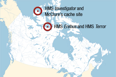
Given the physical and logistical challenges associated with travelling and working in the Arctic, few Canadians experience first-hand the beauty and history of our most northerly places. Parks Canada is pleased to bring this to you through our web content and social media opportunities. Be a part of the search and follow our progress as we continue our attempts at solving the mystery of Franklin’s lost ships, conduct further follow-up work on HMS Investigator and its related sites, such as McClure’s Cache, and learn more about how early Arctic exploration and the search for the North-West Passage shaped the development of our country.
The search for the North-West Passage has captured public imagination for more than 160 years. Parks Canada invites you to continue following the fascinating work of our archaeologists and learn about the history surrounding this epic part of Canada's past. Visit our site again, as updates will be added as more information comes available.
 http://www.pc.gc.ca/eng/culture/expeditions/erebus-terror/equipe-team.aspx
Parks Canada 2010 Arctic Surveys
HMS Erebus and HMS Terror
Meet our Team
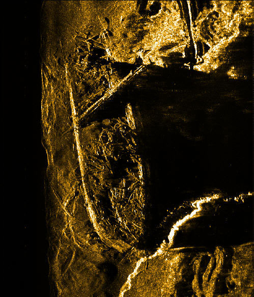
Parks Canada’s Underwater Archaeology Service (UAS) will lead a second archaeological exploration to search for HMS Erebus and HMS Terror, off the coast of Nunavut, with projected dates of August 10-August 31, 2010. The first expedition was conducted in August 2008.
Parks Canada provides underwater archaeology expertise to various levels of government and to non-government organizations, often working in collaboration with them, as it is the case of the HMS Erebus and HMS Terror expedition. This Canadian-led expedition is a collaborative project among Parks Canada, the Canadian Hydrographic Service (CHS) and the Canadian Coast Guard. The partnership combines a breadth of expertise and will inevitably provide new information and add to the body of research on the fate of these ships. If found, all future archaeological investigations will again be led by Parks Canada.
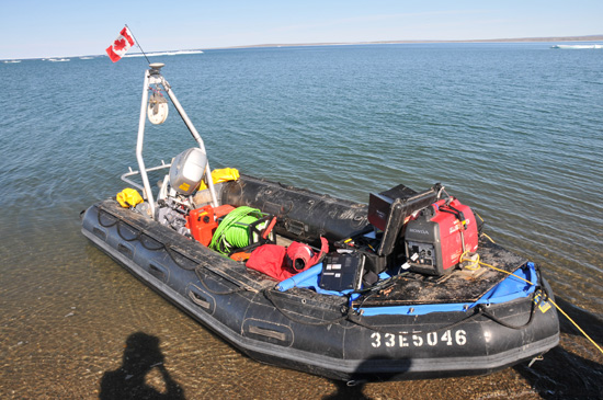
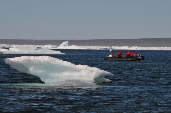
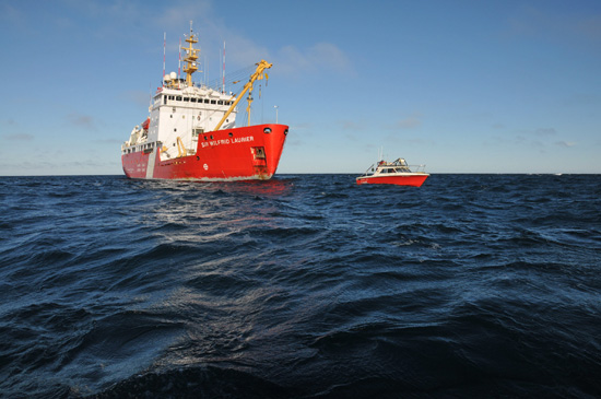
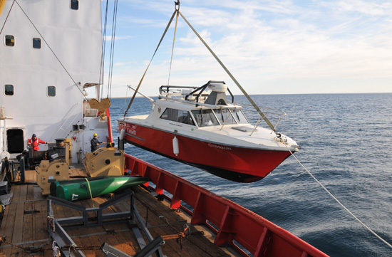
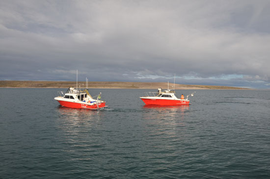
The expedition is staged from CCGS Sir Wilfrid Laurier, a Canadian Coast Guard ice-breaker. The search area falls within uncharted waters and the CHS will provide surveying expertise and technology to help map the area of interest and nearby routes for navigational charts. Information gathered during the search will contribute to improving charts of the Canadian Arctic.
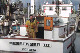
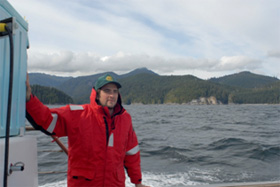
Captain William Noon
© Parks CanadaCAPTAIN WILLIAM NOON,
CCGS Sir Wilfrid Laurier (PDF Fact Sheet - 2.4 Mb) a native of West Vancouver, BC, joined the Canadian Coast Guard in 1981. Captain Noon served as a seaman and then Lifeboat Coxswain in Bull Harbour, Powell River, and Ganges, BC. In 1984 he attended the US Coast Guard Motor Lifeboat Surf Course at Cape Disappointment, Washington and CCG Coxswains Course in Cornwall, Ontario.
After obtaining a bridge watch-keeping certificate, Captain Noon served as Navigation Officer on numerous ships including the CCGS Martha L Black, CCGSNarwal, CCGS Sir James Douglas, CCGS Sir Wilfrid Laurier and CCGS Bartlett in the BC coastal waters and the CCGS Sir Wilfrid Laurierand Arctic Ivik in the Canadian Arctic.
Captain Noon first relieved as Master of CCGS Arctic Ivik in 1995 and was appointed Master of the Buoy Tender CCGS Bartlett in 1997, Captain Noon successively commanded the research ships CCGS Ricker and CCGS John P Tully undertaking offshore oceanographic and SAR missions.
Captain Noon was the superintendent of the Regional Operations Centre (Pacific) 2000-2002, followed by a further command of the CCGS John P Tully, 2003-2009. He was appointed master of CCGS Sir Wilfrid Laurier in 2010.
Captain Noon has attended the Pacific Maritime Technology Institute, Camosun College, and the Canadian Coast Guard College.
His interest in maritime heritage takes up much of his time when not at sea. He recently completed 6 years as trustee for the Maritime Museum of British Columbia and currently sits on the board of the Victoria Classic Boat Festival. Captain Noon is also an active member of the Thermopylae Club of Victoria, named after the famous China clipper. The club was founded by mariners in 1932, having the goal of protecting and preserving the nautical history of Canada’s west coast. His remaining time is spent restoring and cruising aboard his 64 year old wooden boat, Messenger III, a former coastal mission boat.
 Roger Cameron
© Parks Canada
Roger Cameron
© Parks Canada
ROGER CAMERON was born in Kingston, Jamaica and moved to Canada in 1977, settling in Burlington, Ontario. Roger graduated from Sir Sanford Fleming College in 1985 with a diploma in Cartography and subsequently attended York University (Geography).
Roger began his career at Canadian Cartographics, then located in Coquitlam, British Columbia where he produced thematic maps, including an atlas commissioned by the Gitksan Wet’suwet’en Tribal Council to substantiate a land claim in central British Columbia. He then moved to Toronto and was employed by Marshall Macklin Monaghan Ltd. where he worked in topographic mapping and a variety of projects utilizing close-range photogrammetry. In 1998 he began his career as a hydrographer with the Canadian Hydrographic Service at the Canada Centre for Inland Waters in Burlington. Roger has surveyed waters of the Great Lakes, St. Lawrence River, Trent-Severn Waterway and Arctic and produces paper charts and electronic navigational charts from collected data.
Roger was part of a Canadian Hydrographic Service team that operated from the Sir Wilfrid Laurier in 2008 and 2009, and was part of the 2008 team that searched for the Franklin ships. He is currently a Vice-President of the Canadian Hydrographic Association and is Chair of the upcoming 2012 Canadian Hydrographic Conference to be held in Niagara Falls, Ontario. Roger is married with three children and resides in Welland, Ontario.
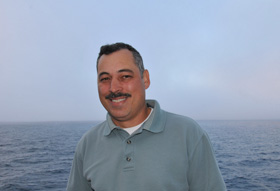
Andrew Leyzack
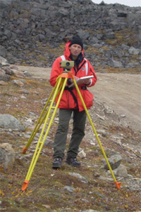
© Parks CanadaANDREW LEYZACK, a graduate of Humber College's Hydrographic and Land Survey Technologist program, Andrew has been surveying for over 20 years, with varied experience in topographic, cadastral, offshore/industrial and hydrographic surveys for nautical charting. He is a Commissioned Canada Lands Surveyor, working as an Engineering Project Supervisor with the Canadian Hydrographic Service, Central and Arctic Region (Federal Department of Fisheries and Oceans Canada). He is presently assigned as Hydrographer-in-Charge of the Western Arctic Survey, Kitikmeot Region.
In addition to supporting Parks Canada's search program (with logistics, personnel, survey launches, sonar and navigation) he is leading hydrographic surveys in one of the most poorly charted areas of the Arctic. The Kitikmeot Region, as it is known, has over the past decade experienced measurable increase in community growth, resource extraction and vessel traffic (deep sea cargo ships, passenger liners and private yachts). The current trend in ice conditions has had a positive influence on the volume of vessel traffic, particularly smaller craft. The waters in this part of the Western Arctic are generally shallower than those of the Eastern Arctic and often vessels are looking for alternative routes around the ice edge when it is present. Our work has been focused on widening the existing routes, carving out new alternate routes for ice avoidance and preparing large scale charts for the various communities. Additionally many of the existing charts are inaccurate and incompatible with modern GPS navigation. Current charting, particularly that which covers the "search area", shows more empty space than soundings. In fact, a good part of our previous joint mission with Parks Canada (2008) was spent clearing a narrow route to safely bring our supporting platform, the Canadian Coast Guard icebreaker Sir Wilfrid Laurier, some 25 miles south of the existing shipping lanes into the uncharted waters of the search area. In this case, the work can be likened to cutting a new road through a wilderness, where there is little or no indication of the topography or what's around the bend.
 Glenn Macdonald
© Parks Canada
Glenn Macdonald
© Parks Canada
GLENN MACDONALD began working with the Canadian Hydrographic Service in 1996. In recent years his work has focused on tides, currents, and water levels. He was part of the Canadian Hydrographic Service group that teamed with Parks Canada on the 2008 archaeological survey to search for the Franklin vessels. Glenn is a songwriter whose most recent collection is Attendance (2010). He has a wife and three children and finds that the disciplines of hydrography, family and music exist harmoniously.
 Glenn Toldi© Parks Canada
GLENN TOLDI was born in Burlington, Ontario. Glenn completed his Bachelor of Science degree in Geography and Biology at Trent University in 1992 then studied at Sir Sanford Fleming College (School of Natural Resources) where he earned a diploma in Cartography/GIS Technology in 1994. A fascinating opportunity to live in and travel throughout Australia afforded Glenn valuable work experience. He worked as a Cartographic technician for Cartodraft Ltd. in Sydney Australia in 1995.
Upon his return to Canada in 1996, he secured a position with The Canadian Hydrographic Service as a Hydrographer. Glenn has subsequently settled in Smithville, Ontario with his wife and two boys. He has been an avid yearly participant in Arctic surveys since before his oldest son was born.
Working as a Hydrographer since 1997 with The Canadian Hydrographic Service, he has taken part in many Hydrographic surveys throughout the Canadian Arctic and across the Great Lakes. His experience with Hydrographic surveys includes single beam, side scan and multibeam sonar operations and data processing. Glenn also creates Electronic Navigational Charts and Nautical Paper Charts based out of the Canada Centre for Inland Waters in Burlington Ontario. Recently, Glenn was part of the Hydrographic group which teamed with Parks Canada on the 2008 archaeological survey to search for the Franklin vessels. Glenn worked from 2008-2009 aboard the CCGS Sir Wilfrid Laurier as data processor during Arctic surveys and will continue in this role throughout this summer.
Parks Canada
 Ryan Harris
© Parks Canada
Ryan Harris
© Parks Canada
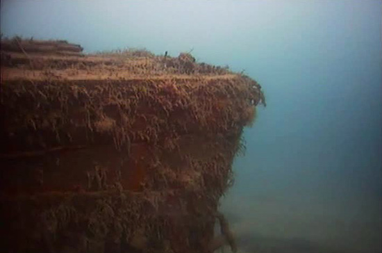
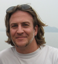
RYAN HARRIS was born in Calgary, Alberta. Ryan completed his Bachelor’s degree in Anthropology at the University of Toronto. He then studied at East Carolina University, in Greenville North Carolina, where he graduated with his Masters in Maritime History and Nautical Archaeology. Working as an underwater archaeologist with Parks Canada since 1999, he took part in more than 50 underwater archaeology projects throughout his career, including the War of 1812 shipwrecks
Hamilton and Scourge, an
American PBY-5A airplane in Longue-Pointe-de Mingan (Québec), RMS
Empress of Ireland (1914) (Québec),
16th-century whaling vessels in Red Bay (Newfoundland and Labrador), the 18th-century French shipwrecks of the
Fortress of Louisbourg National Historic Site (Nova Scotia) and of the Battle of the
Restigouche National Historic Site(Québec). His professional fields of research include historic ship architecture and remote-sensing applications to archaeological surveys. He has been actively involved in surveys all across Canada, from
L’Anse aux Meadows National Historic Site (Newfoundland and Labrador) to
Gwaii Haanas National Park Reserve and Haida Heritage Site (British Columbia), and from
Saguenay-St. Lawrence Marine Park (Quebec), to the
Rideau Canaland
Trent-Severn Waterway National Historic Sites (Ontario). He has also participated in underwater archaeology projects in the United States and in Bermuda. In 2008, Ryan was responsible for Parks Canada for the remote-sensing operations of the archaeological survey to search for the Franklin vessels.
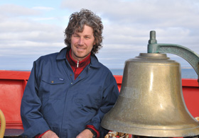
Jonathan Moore
© Parks CanadaJONATHAN MOORE was born in Banbury, England, and moved to Kingston, Canada with his family at the age of five. He studied classical studies and archaeology at Queen’s University where he received a Bachelor’s degree in 1991. While at university he learned to dive and began his involvement in underwater archaeology. He went on to complete a Master’s degree in Maritime Studies at the University of St. Andrews, and began his professional career in underwater archaeology in England and Scotland shortly thereafter.
He returned to Canada in 1994 and that year began working with Parks Canada’s Underwater Archaeology Service. He has worked on over 50 underwater archaeology projects across Canada on a range of subjects and topics, from historic shipwrecks to submerged prehistoric landscapes and sites. He has directed underwater surveys at a range of sites including,
L’Anse aux Meadows National Historic Site (Newfoundland and Labrador),
Rideau Canal National Historic Site (Ontario) and
Gwaii Haanas National Park Reserve and Haida Heritage Site (British Columbia). He recently directed a 2007-2009 archaeological study of the United States Navy shipwrecks
Hamilton and Scourge sunk in 90 meters (300 feet) of water in Lake Ontario in 1813. His professional areas of research and interest include War of 1812 shipwrecks, ship abandonment, submerged palaeo-landscapes, the effects of invasive mussel species on underwater cultural resources, archival research and local history. Jonathan was part of the Parks Canada team on the 2008 archaeological survey to search for the Franklin vessels.
Expedition Partners
Partner Information - HMS Erebus and HMS TerrorExpedition
Parks Canada Agency
Parks Canada, an agency of the federal government, protects and presents nationally significant examples of Canada's natural and cultural heritage in ways that ensure their ecological and commemorative integrity for present and future generations. Parks Canada's Underwater Archaeology Service (
UAS) is a team of seven underwater archaeologists based in Ottawa, Ontario. The team–the only one of its kind in Canada, conducts underwater archaeological projects across the country, mainly at Canada's national historic sites, national marine conservation areas and national parks. It also provides underwater archaeology expertise to various levels of government and to non-government organizations, often working in collaboration with them, as it is the case of the HMS
Erebus and HMS
Terror expedition. The Parks Canada crew for the expedition will be Ryan Harris, Senior Marine Archaeologist for the
UAS and Project Director, and Jonathan Moore, Senior Marine Archaeologist for the
UAS. Mr. Harris and Marc-André Bernier, Chief of the
UAS, will serve as Parks Canada's principal media contacts for the HMS
Erebus and HMS
Terror Expedition.
The Canadian Coast Guard (
CCG) has a long and proud history of service in the Arctic. As early as 1884, government survey expeditions sought a shorter navigational route to Western Canada through Hudson Bay and Strait to meet the needs of a growing economy. Arctic sovereignty patrols began in 1903 with CGS
Neptune. Coast Guard has served Arctic Canada for generations. Every year, from late June to early November, the
CCG deploys one light, two heavy, and four medium icebreakers to the Arctic. These icebreakers operate in a harsh climate and some of the most challenging sea ice conditions in the world. They are often the first vessels into the Arctic each shipping season and the last to leave. There are also two
CCG vessels on the Mackenzie River and Beaufort Sea. The officers and crew of six icebreakers are deployed to the Arctic in summer once southern icebreaking operations are complete. The reassuring and longstanding presence of Coast Guard personnel and assets in the Arctic underscores Canada's national sovereignty and helps keep Arctic waterways open, safe, and clean. The women and men onboard Coast Guard vessels who serve in the Arctic each year have a wealth of knowledge and experience. Many of the Commanding Officers of the icebreakers have more than 20 years of service in the demanding Arctic marine environment.
CCG personnel also visit Arctic communities to tap into local and traditional knowledge. Much of the success in delivering Coast Guard programs and services is due to the attention paid to human elements. Many of
CCG Arctic activities are delivered in partnership with other federal departments including Parks Canada.
Fisheries and Oceans Canada, a department of the federal government, contributes to providing safe and accessible waterways for Canadians. The
Canadian Hydrographic Service (CHS) is a Directorate of DFO's Science Sector and is responsible for charting the navigable waters of Canada to produce nautical charts and other publications that promote safe navigation.
CHS has carried out hydrographic surveys in the north dating back to as early as 1910. Surveys, using ice-capable ships and smaller launches deployed from those ships, have been the most common method to collect hydrographic information. Ice camps established in cooperation with Polar Continental Shelf Project in the 1970s and 80s were another means of collecting data in this harsh environment. The
CHS Central and Arctic Region has a team of hydrographers that collect and manage hydrographic data to create nautical publications for the Arctic. The search area falls within uncharted waters and the
CHS will provide surveying expertise and technology to help map the area of interest and nearby routes for navigational charts. Information gathered during the search will contribute to improving charts of the Canadian Arctic. Andrew Leyzack, Engineering Project Supervisor, will be Hydrographer-in-Charge and scientific authority aboard ship providing liaison with the Commanding Officer for all survey operations. Hydrographic technical support will be provided by multi-disciplinary hydrographers, Glenn Toldi, Glenn Macdonald, and Ryan Battista.
The Department of Culture, Language, Elders and Youth's mandate is to preserve and enhance Nunavut's culture, heritage and languages. The department's Culture and Heritage Division is responsible for the management of Nunavut's archaeological heritage. It administers Nunavut's archaeological research permit system, conducts archaeological training and research projects in collaboration with community and land claims agencies, and provides expertise on archaeological matters to government and non-government organizations. In recent years, Dr. Douglas Stenton, Director of the Culture and Heritage Division, assisted by Dr. Robert Park, University of Waterloo, have led investigations on islands near the underwater survey area for sites containing evidence of the Franklin expedition. The Government of Nunavut is also playing a role ensuring continuing liaison with the Inuit people of the Community of Gjoa Haven.
The project appreciates the ongoing support of the community of Gjoa Haven and the Inuit Heritage Trust. In particular, local historian and Franklin researcher Louie Kamookak, who has brought his considerable depth of experience and insight into Inuit traditional knowledge to the search, and to the Gjoa Haven Hamlet Council, who is to be thanked for its kind assistance and hospitality.
The British High Commission in Canada works to advance the UK's interests in a safe, just and prosperous world by developing and maintaining a wide range of substantive partnerships with Canada of real value to both countries; developing business between the UK and Canada, and encouraging Canadian companies to invest in the UK and; providing effective and courteous public services.
A 1997 memorandum of understanding (
MOU) between Great Britain, as owner of HMS
Erebus and HMS
Terror, and Canada, as the nation in whose waters they are believed to have been lost, assigns control over “site investigation, excavation, or recovery of either of the wrecks or their contents” to Canada, in the event of their discovery.
Suggested Reading
For further information and suggested reading:
North-West Passage
Delgado, James P., Across the Top of the World, The Quest for the Northwest Passage. Vancouver, B.C.: Douglas & McIntyre Ltd, 1999.
HMS Investigator
Minister Jim Prentice's long-standing fascination with the story of HMS
Investigator led him to read and review
The Ice Passage: A True Story of Ambition, Disaster, and Endurance in the Arctic Wilderness by Vancouver writer Mr. Brian Payton.
The Ice Passage is a narrative nonfiction account of the final voyage of HMS
Investigator. The book review by Minister Prentice (
Ship Frozen in Ice, Crew Gets Out Alive) appeared in the December 2009-January 2010 publication
Options Politiques.
Read the review on the Institute for Research on Public Policy's Web site (PDF 35 KB)M'Clure, Robert. The Discovery of the North-West Passage. Edited by S. Osborn. London: Longman, Brown, Green and Longmans 1856. Reprint Edmonton: Hurtig 1969.
Miertsching, Johann. Frozen Ships: The Arctic Diary of Johann Miertsehing, 1850-1854. Translated and edited by L. H. Neatby. Toronto: Macmillan 1967.
Payton, Brian. The Ice Passage: A True Story of Ambition, Disaster, and Endurance in the Arctic Wilderness. Toronto: Doubleday Canada 2009, A division of Random House of Canada Limited.
Franklin Expedition
Beattie, Owen and John Geiger, Frozen in Time: Unlocking the Secrets of the Franklin Expedition. Saskatoon: Western Producer Prairie Books, 1989.
Cyriax, R.J. Sir John Franklin's Last Arctic Expedition. London: Methuen and Co., 1939
Gilder, William H. Schwatka's Search: Sledging in the Arctic in Quest of Franklin Records. New York: Charles Scribner's Sons, 1881.
McClintock, Francis Leopold. The Voyage of the "Fox" in the Arctic Seas: A Narrative of the Discovery of the Fate of Sir John Franklin and His Companions. Philadelphia: Porter and Coates, 1859. Reprint Edmonton: Hurtig Publishers, 1972.
Nourse, J.E., ed. Narrative of the Second Arctic Expedition Commanded by Charles Francis Hall. Washington: Government Printing Office, 1879.
Woodman, David C., Unravelling the Franklin Mystery: Inuit Testimony. McGill-Queen’s Native and Northern Series #5, Montreal: McGill-Queen’s University Press, 1992.
Woodman, David C., Strangers Among Us. McGill-Queen’s Native and Northern Series #10, Montreal: McGill-Queen’s University Press, 1995.

")
")
")
")
")


